We had to make a big choice for today’s ride. Being Labor Day weekend, many people warned us of volumes of edgy traffic and urged us to stay away from narrow windy shoulderless roads like the one up and down Mingus Mountain. Other folks asked the pressing question, “Are you here to chalk up miles or see the most beautiful scenery the region has to offer?”
I was still debating this question late at night when Maureen arrived at the WarmShowers house where we were staying for the night. After a quick introduction that revealed she grew up in the area where I live, I mentioned my quandary. She is a forest ranger in the area and knows it well. She said, “Both voices are correct. It is dangerous and it is beautiful. Go with your gut.” My gut was screaming Mingus Mountain, so that became the plan.
It was possible to do it today because Andrew from Bikesmith Cyclery had my bike ready at 11 PM last night. All the pieces of the puzzle had come together. Andrew had even rebuilt my derailleur. Even though he had assured me it would function like the previous one, I worried because its arm was shorter.
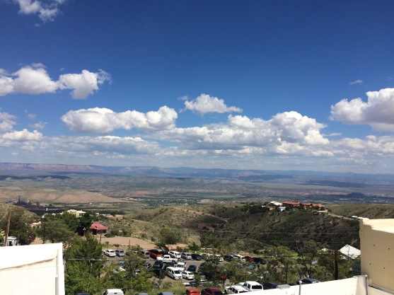
This morning, we headed for Mingus Mountain. It was described as a 12 mile climb, but only five miles were really tough. I was using the new derailleur and was working harder than I like. I prefer to have my granny gear as my insurance policy, my secret sauce for doing mountains, and I thought I was already using it. I could see the road winding way up the mountain and I was worried. Then I looked down and realized I was not yet in my granny gear! Hooray! Up and up I went. The bike and I did fine, though very slowly and deliberately as always. Ironically, the Prius had a moment — the master warning light turned on. From turnout to turnout, Susie figured it all out with the owner’s manual. Way to go, Susie!

I videotaped the stunning ascent, but the descent would have been more thrilling video. After lunch in the town of Jerome that clings to the mountainside, I did record the rest of the descent. I used my brakes a fair amount because there were many hairpin turns, the slope was steep, and some of the curves had gravel in the outside edge where I usually cycle. I found drivers to be very respectful. I stopped at least three times on the way down, ostensibly to take photos, but really to take a break from the descent.

We are staying tonight with WarmShowers hosts, Peter and Jenny, in Cornville. They are cyclists and have about 16 bikes in their house. They have cycled all over the world and will soon visit Denmark for an extended bike tour.
Ride details
Start location: Prescott AZ
End location: Cornville AZ
Distance: 44.9 miles
Cumulative distance:
Elevation gain: 2635 feet mostly on Mingus Mountain, but much more downhill than up
Features: Perfect weather, spectacular climb
Strava track: https://www.strava.com/activities/699514921/overview

Glad you opted for Mingus/great scenery photo. Getting a bit of wind in Delaware. Nothing too bad though.
LikeLike
Wind and temp behaving for last few days.
LikeLike
Another successful accomplishment. Way to go! It looks amazing!
LikeLike
One gorgeous day ride after another! Today we go to flagstaff, then we get our first rest day.
LikeLike
Glad you’re enjoying yourself as well as fulfilling this dream. Been to Jerome, cute town – but not by bike – yet!
LikeLike
Karen, you would LOVE Jerome by bike!
LikeLike
You are in some beautiful country. We toured AZ by motorcycle in September years ago, with Prescott, Jerome, Sedona, the south rim of the Grand Canyon, and standing on the corner in Winslow being some of our favorite memories. Glad you are enjoying it. Not sure I’d want to do it on a bicycle, but the sense of accomplishment must be amazing.
LikeLike
It’s totally doable by bike!! One gorgeous ride after another, most about 50 miles each so far.
LikeLike